- SERVICES
Thermal Drone Services
Drone thermal imaging services utilize unmanned aerial vehicles equipped with thermal cameras to capture infrared radiation emitted by objects. These services analyze temperature variations in buildings, infrastructure, and landscapes, identifying issues like leaks, electrical faults, and insulation problems. They aid in search and rescue operations, industrial inspections, wildlife monitoring, and agricultural assessments by detecting heat signatures.
From industrial predictive maintenance to agriculture crop inspections, drone thermal imaging offers versatile solutions for diverse applications, enhancing safety and decision-making processes across various sectors.
Deliverables
- Infrared Images with Before and After
- Infrared Videos with Before and After
- 2D Infrared Maps with Before and After
- Detailed Inspection Reports
- Realtime Infrared Footage
APPLICATIONS
Innovative Solutions
Roof Inspection
Utilizing advanced aerial thermography, we record roof temperature variations from above, employing state of the art infrared cameras. This technology enables precise detection of trapped moisture areas and more. Our detailed reports on thermal anomalies provide valuable insights for various buildings, facilitating proactive maintenance decisions.
Power Line and Electrical Inspection
Powerline and electrical thermal inspections using a drone detects hot spots which can indicate flaws in the system. This information is crucial to help maintain the integrity of infrastructure, prevent outages, and ensure a reliable power supply.
Power Line and Electrical Inspection
Powerline and electrical thermal inspections using a drone detects hot spots which can indicate flaws in the system. This information is crucial to help maintain the integrity of infrastructure, prevent outages, and ensure a reliable power supply.
Solar Panel Inspection
Drone thermography allows for the quick and comprehensive identification of defective solar panels. The thermal imaging technology detects variations in temperature, highlighting areas of potential malfunction, such as hotspots or cold spots, which may indicate electrical or structural issues
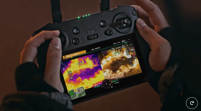
Fire fighting operations
Drones get a birds eye view to help assess fires and can eliminate the need for firefighters to enter dangerous areas. Our thermal camera drones identify the fires hotspots and capture it’s progress to aid in fire suppression in both structural and wildland operations.
We create geo-referenced thermal orthomosaic maps for wildland fire hot spot detection to aid with locating and snuffing out smouldering areas. Our Thermal camera drones provide real time data to assist in the quickest extinguishment possible.
Forest Fire Operations
We work with Alberta forestry services to help suppress the spread of wild fires. Our thermal camera drones seek out hot spots in smoldering wild fires. The hotspot data is then compiled and sent to ground and air crews to be extinguished.
Frac Leak Detection
Safely locate frac leaks night and day on drilling operations. Our thermal drones save on unnecessary time walking through unstable terrain looking for frac leaks.
Wildlife Inspection
Efficiently identify animals living in the area before clearing sections of land. Mitigate risk of birds near tailing ponds or other dangerous areas.
Wildlife Inspection
Efficiently identify animals living in the area before clearing sections of land. Mitigate risk of birds near tailing ponds or other dangerous areas.